Predicted Magnetic Position catalogue
Catalogue contents
The Predicted Magnetic (or Scientific) Position (PMP) catalogues contain
time-tagged records at five minute intervals giving predicted values of:
the invariant latitude (Lambda) of the spacecraft. This is calculated from
the predicted geometric position of the spacecraft
using the CNES MAGLIB library as discussed below. The invariant latitude is set to null outside the magnetosphere
the magnetic field strength (B) at the spacecraft. This is also calculated
from the predicted geometric position of the spacecraft using the CNES
MAGLIB library. Its value is set to null outside the magnetosphere
the McIlwain L-parameter (L) of the spacecraft. It is derived from the
invariant latitude L using the standard formula L=sec2 Lambda.
Its value is set to null outside the magnetosphere.
the magnetic local time (MLT) of the spacecraft. It is derived from the
longitude in the
solar-magnetic (SM) co-ordinate system using the formula
MLT = 12.0 + Longitude / 15.0 (see page 500 of the JSOC paper that was published as part of the Cluster mission special issue of Space Science Reviews (Hapgood et al., 1997)). The SM longitude is calculated from the predicted
geometric position in GSE coordinates using the algorithms described
in Hapgood (1992). MLT has a valid
value outside the magnetosphere.
JSOC use of MAGLIB
The calculation of invariant latitude (and L-values) by JSOC is described in section 3.5 of Hapgood et al. (1997). This notes the use by JSOC of the MAGLIB library for these and related calculations. Additional information is available in the JSOC Planning Scenario (JSOC technical note: DS-JSO-TN-0007).
The MAGLIB library was provided to JSOC by CNES in 1995, as a contribution to the overall Cluster project (see acknowledgement in the JSOC paper above). The MAGLIB version used by JSOC is version 1, which was released in 1991, and was adapted by JSOC as mission needs evolved between 1995 and 2024. In June 2000 JSOC compared results with the MAGLIB author at CNES to verify the consistency of results between JSOC and CNES. JSOC did not use later MAGLIB releases from CNES (now version 6).
The key evolution, as planned in the JSOC paper above, was a series of updates by JSOC to use the latest versions of the International Geomagnetic Reference Field (IGRF) as a representation of Earths internal magnetic field. IGRF 1995 was used at the start of the Cluster science mission, with updates to IGRF version 10 in 2006, to version 11 in 2010, to version 12 in 2016 and version 13 in 2020. Version 13 was the current version at the end of the Cluster science mission in September 2024; version 14 being released in November 2024. Other updates were made to ensure compatibility with other codes used by JSOC, and to fix a minor bug that caused the code to get stuck in an endless loop.
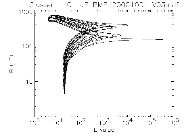
Sample plot
The plot below shows an example of data from a PMP catalogue. It shows
the predicted locus of Cluster spacecraft 1 in B/L co-ordinates for the
month of October 2000. The region of Cluster radiation belt passages is
represented by the branch at the upper left of the plot, which shows the
spacecraft reaching down to L values well below 10. Note that Cluster can
reach enormous L-values because its polar orbit takes it very close to
the dipole axis; the highest value in this plot (~20000) represents an
invariant latitude of 89.6 degrees.
The plot was produced using a simple IDL routine which can be viewed
here.
The CDF file was read using NSSDC's
CDAWlib library.
References
Hapgood, M. A. "Space physics coordinate transformations: A user guide." Planetary and Space Science 40.5 (1992): 711-717. doi: 10.1016/0032-0633(92)90012-D. Also Corrigendum at doi: /10.1016/S0032-0633(97)80261-9
Hapgood, M. A., Dimbylow, T. G., Sutcliffe, D. C., Chaizy, P. A., Ferron, P. S., Hill, P. M., & Tiratay, X. Y. (1997). The joint science operations centre. Space Science Reviews, 79(1), 487-525. doi: 10.1023/A:1004954504114
Last updated by Mike
Hapgood ( mike.hapgood@stfc.ac.uk),
7 October 2025
|